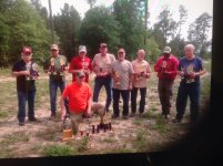
Walker County VFS and HBR Results

jackie schmidt

New member
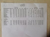
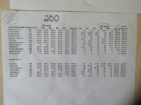
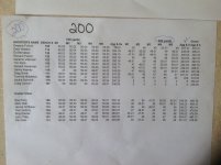
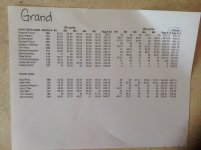
Here are the results of today's VFS and HBR 100/200 held at Walker County Benchrest.

It was a good day to shoot. Windy, yes, but still, a good day.

Jackie Schmidt won the 100 with a 250 23x, Dwayne Pullum won the 200 with a 247 1x. Dwayne won the Grand Agg with a combined 497 21x.

Ray Perry won both the 100, (250 15x), and 200 (245 4x) in the HBR class, and the Grand Agg with a 495 19x. Great shooting by Ray.

I have a nice picture in my IPad of all of those that garnered trophys, but the Site will not let it download.


http://benchrest.com/attachment.php?attachmentid=19280&stc=1&d=1491103662


http://benchrest.com/attachment.php?attachmentid=19281&stc=1&d=1491103706

http://benchrest.com/attachment.php?attachmentid=19282&stc=1&d=1491103773

http://benchrest.com/attachment.php?attachmentid=19283&stc=1&d=1491103828
 

Attachments

  • IMG_1766.JPG
    IMG_1766.JPG
    1.2 MB · Views: 399
  • IMG_1767.JPG
    IMG_1767.JPG
    1.2 MB · Views: 383
  • IMG_1768.JPG
    IMG_1768.JPG
    1.2 MB · Views: 370
  • IMG_1769.JPG
    IMG_1769.JPG
    1.3 MB · Views: 385
Last edited:
Jackie, I didn't see this until yesterday. I'll try to make one of the next ones they have coming up. I went to the clubs web site and following the contact tab I went to the map for the club's location. I switched to google earth at that point but was unable to identify the range from the pictures. Guess I wouldn't have made a good interpreter for aerial photography. Anyway, I would have thought that the roof for the benches would have been clearly visible on the satellite photos. I was down to seeing individual trees so the roof over the benches should have been visible. Any hints you might have in locating the range would be appreciated.
 
Jackie, I didn't see this until yesterday. I'll try to make one of the next ones they have coming up. I went to the clubs web site and following the contact tab I went to the map for the club's location. I switched to google earth at that point but was unable to identify the range from the pictures. Guess I wouldn't have made a good interpreter for aerial photography. Anyway, I would have thought that the roof for the benches would have been clearly visible on the satellite photos. I was down to seeing individual trees so the roof over the benches should have been visible. Any hints you might have in locating the range would be appreciated.

I don't think the "Google Earth" photo is anywhere near up to date. There is no evidence of a Rifle Range on it.

The Range is easy to find. Take 75 northwest out of Huntsville for 3 miles to FM 1696. Take a left and go exactly 7.1 mils to Scales Ranch Rd. Take a left for about 1/8 mile, the entrance is on the left.
 
Last edited:
I don't think the "Google Earth" photo is anywhere near up to date. There is no evidence of a Rifle Range on it.

The Range is easy to find. Take 75 northwest out of Huntsville for 3 miles to FM 1696. Take a left and go exactly 7.1 mils to Scales Ranch Rd. Take a left for about 1/8 mile, the entrance is on the left.

The range has been there for at least a year. I would thought the photos would be updated more frequently. Oh well. I'll be coming from the North so I'll have a different exit. The pointer on the map shows the entrance being on the right when you turn on to scales so I am glad you included that tidbit. I was looking at photographic data all over the area North of the road
 
Back
Top